- Home
- Administration
- Aeronautics
- Business with WYDOT
- Construction Projects
- Driver License and Records
- Economic Stimulus Projects (ARRA - TIGER)
- Engineering and Technical Programs
- Fuel Tax
- Highway Safety
- Human Resources
- Manuals and Publications
- News and Information
- Permits
- Planning/Projects/Research
- Titles, Plates and Registration
- Travel
- Trucking / Commercial Vehicles
- Vehicle Business Regulation
- Wyoming Highway Patrol
- Search
- Sitemap

WYDOT’s travel website reaches 1 billion views; new road, weather features added
May 11, 2017
Motorists in need of road and weather conditions will have access to new map features on the Wyoming Department of Transportation’s travel website, which broke a record in 2016 with more than 1 billion views.
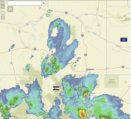
The map on WYDOT’s 511 Road and Travel Information website now includes real-time weather radar, long-term weather watches and warnings and short-term weather advisories from the National Weather Service.
The public relies not only on the map, but also on the entire website for its travel needs.
In 2016, the site had 1.2 billion views, which included views of the map and the other parts of the website. So far in 2017 for January through March, the website had 401.8 million views.
“This is an indication of how the agency is moving forward in the realm of transportation technology,” said WYDOT Director Bill Panos. “People rely on the information we provide on the website to let them know about travel conditions. It’s another way we can help further driver safety.”
WYDOT continually adds new features to the map in response to public demand.
“Each year we see the demand for travel information grow,” said Vince Garcia, WYDOT’s GIS/ITS manager. “People rely on this information, so they can make good travel decisions. Year after year our website views grow, and we’re continually breaking records for views.”
The new weather radar shows viewers a real-time animation of precipitation impacting an area. The information loops over the past hour, giving viewers the path the storm is heading.
For long-term watches and warnings, the map shows impacted areas as a certain colors, which represent such events as flood watches, heat warnings, high-fire danger and others.
Short-term weather warnings will also show an impacted area as a dashed color depicting tornados, severe thunderstorms or flash floods.
The new map also has a road conditions layer, which was on a previous version of the map. When that layer is turned on, the road impact layer is automatically turned off.
The road conditions layer provides surface conditions such as dry, wet, slick spots, and closed. It also gives atmospheric conditions such as rain, fog and snowfall.
The road impact layer alerts motorists of conditions based on low, moderate, high, partial closure and closed. Users can easily get detailed information by clicking on any road.
“We’re always looking to enhance the 511 Travel Information website to provide our customers with the best possible tool to use when making travel decisions,” said Ali Ragan, GIS/ITS project manager. “Our users can access the map, see real-time information and conditions and then make informed decisions about traveling.”
Motorists can visit the 511 website to view the map and other information. They can also provide comments about the map by clicking on the “comment” link on the map page.